Wildfires are exploding across the West, especially in California, where the Park Fire has now grown to be the biggest in the state this year.
The largest of several wildfires in the state is the Park Fire, burning in Butte and Tehama counties, just north of Chico, grew to over 350,000 acres and was 10% contained as of Saturday evening. At least 134 structures have been destroyed by the blaze, which has grown to be the 7th largest fire recorded in California history in only a few days.
California Gov. Gavin Newsom declared a State of Emergency for Butte and Tehama counties due to the Park Fire, as well as Plumas County, due to the Gold Complex Fire, which combined have burned more than 424,000 acres.
“We are using every available tool to protect lives and property as our fire and emergency response teams work around the clock to combat these challenging fires. Stay safe and remain alert for instructions from local authorities as dangerous fire weather conditions continue,” Newsom said in his statement on Friday.
Ronnie Dean Stout II, 42, has been arrested on suspicion of arson for starting the Park Fire after he allegedly pushed a burning car into a gully in Bidwell Park, near Chico, according to Butte County District Attorney Mike Ramsey.
There are more than over 2,400 personnel, six helicopters and 153 fire engines assigned just to the Park Fire.
The Lake Fire, in Santa Barbara County, is the second-largest burning in the state at the moment at over 38,000 acres, though it is 90% contained after sparking July 5.
Meanwhile, farther north, the Durkee Fire in Oregon had grown to over 288,000 acres on Friday morning with 20% containment, according to the Oregon/Washington Bureau of Land Management. It was sparked on July 17 by a lightning strike and has grown to the largest fire in the country this year.
More than 500 people fighting the fire, as rain fell overnight in the area, providing some relief for firefighters.
The pilot of a single-engine fire tanker carrying retardant was found dead on Friday in Grant County in eastern Oregon after the aircraft was reported missing, according to the Bureau of Land Management.
Smoke spreads across several western states
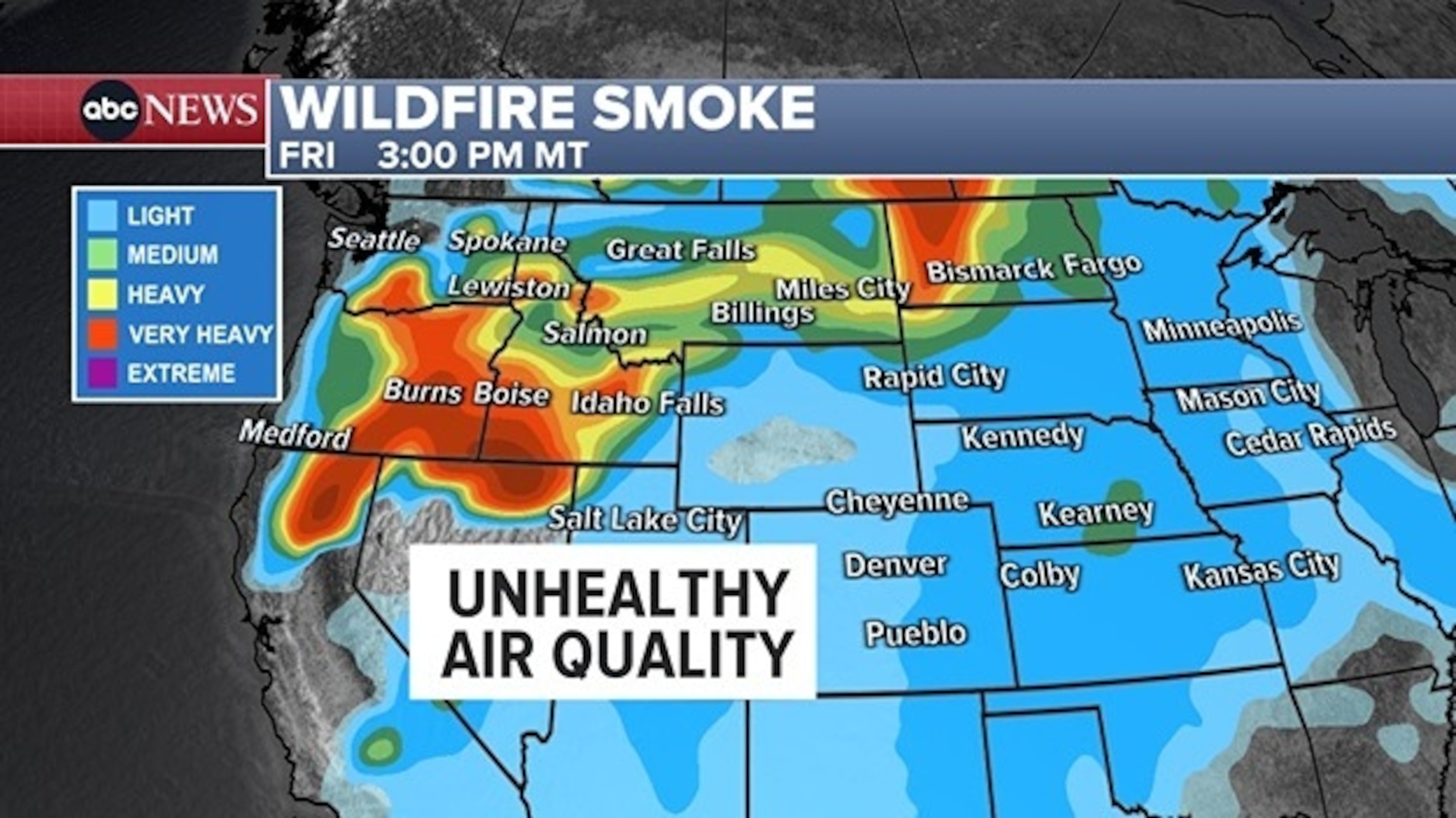
Wildfires burning in the West are creating unhealthy smoke conditions across several states.
ABC News
The smoke from fires in Northern California and Oregon is spreading across several states, including Idaho, Montana and North Dakota, which will all see regions under “very heavy” smoke conditions — the second-worst level.
The Air Quality Index is expected to rise above 150 in Boise, Idaho, on Friday, which would put it in the “unhealthy” category, the fourth of six levels. In Butte, Montana, the Air Quality Index was forecast to be in the 100 to 150 range and “unhealthy for sensitive groups.”
As wildfires continue to rage across California, the latest updates on the situation are crucial for residents and officials to stay informed and safe. With the increasing frequency and intensity of wildfires in recent years, it is more important than ever to have access to accurate information on the locations of active fires and the extent of smoke pollution in the area.
One of the most valuable resources for tracking wildfires in California is the Cal Fire website, which provides real-time updates on the status of fires, containment efforts, and evacuation orders. The website also features an interactive map that allows users to see the locations of active fires, as well as information on air quality and smoke forecasts.
In addition to the Cal Fire website, there are several other online resources that provide valuable information on wildfires and smoke maps in California. The National Interagency Fire Center (NIFC) offers a comprehensive map of active wildfires across the country, including those in California. This map provides detailed information on each fire, including size, containment status, and potential threats to communities.
Another useful tool for tracking wildfires and smoke pollution is the AirNow website, which provides real-time air quality data for locations across the country. This website offers a color-coded map that shows areas with unhealthy levels of pollution due to wildfires, allowing residents to take precautions to protect their health.
As wildfires continue to burn in California, it is important for residents to stay informed and take necessary precautions to stay safe. This includes staying updated on the latest information from official sources such as Cal Fire, NIFC, and AirNow, as well as following any evacuation orders or air quality advisories issued by local authorities.
By staying informed and taking proactive measures to protect themselves and their communities, residents can help mitigate the impact of wildfires and smoke pollution in California. With the latest updates on wildfires and smoke maps readily available online, residents can make informed decisions to safeguard their health and well-being during this challenging time.